All my cycle routes are chosen not just because they provide interesting and challenging riding. I also pick routes that will take us past areas of interest, historically or geologically. The Salisbury to Stonehenge ride (one of my new Wiltshire guided routes) is no exception. However, what most people don’t realise is that we aren’t just riding to and from two fascinating locations, we’re also cycling through many more. The Normanton Down Barrows are just one of them.
An old Drover’s road
As our route leaves Stonehenge heading back towards Salisbury, we cycle in the footsteps of centuries, possibly even millennia. ‘Drover’s roads’ can be found across the country and were used historically for moving livestock around, probably to markets but perhaps also to better grazing. They became established in the medieval period but use of them increased following the industrial revolution, when populations moving into towns and cities increased the demand for food in those areas. It’s thought that many Drover’s roads followed much older trackways, dating back to pre-Roman and perhaps even Bronze Age periods. Following this route little-used today really sets the scene to cycle past Normanton Down Barrows.
Bronze Age burials
Just south of the ancient and famous site of Stonehenge, we cycle through a landscape that bears the centuries old evidence of human activity. The 30-plus mounds of Normanton Down “includes long barrows, bowl, bell and disc barrows, amongst them the famous Bush Barrow and several other mounds containing rich burials which helped to define the ‘Wessex Culture’.”* Although farming has damaged some of the historic features, the barrows are still visible in the fields and countryside. A couple of the barrows are “of distinctly Neolithic type”* (that is, dated to between about 10,000 and 2,000 BCE), the remainder are thought to be Bronze Age (a period from about 3300 BCE to around 1200 BCE).
Over the centuries, there was much speculation over what barrows in general were used for. Today, it is widely recognised that they were constructed as monuments to commemorate the dead. In some cases, individuals (or groups of individuals) were actually buried under them; in other cases, no remains have been found so it is believed they were the focus for cremations or religious ceremonies. Their location, often on prominent places or near water sources, are thought to have also served as meeting points for communities or perhaps as territorial markers.
Bush Barrow Chieftan
Less than half a mile to the south of Stonehenge lies Bush Barrow, on the top of the Normanton Down Ridge. Bush Barrow can today be seen from Stonehenge to the south of the A303. In the Bronze Age, it was in a key ceremonial position and was one of over 200 Bronze Age burial mounds that clustered around Stonehenge. As people approached along the Avenue to celebrate the winter solstice, the sun would set in a blaze of red behind Stonehenge. Bush Barrow lay directly under the path of the setting sun and would have stood out as a gleaming white chalk mound silhouetted on the horizon.
The barrow was raised over the burial of a Chieftain and is Britain’s richest Bronze Age burial find. Near his right arm, two large daggers of brass were found. The largest of the daggers probably came from Brittany, and its’ handle had been richly ornamented by an immense quantity of minute gold rivets no thicker than the smallest pin head.
History coming alive
This is just one of the many reasons why I enjoy leading rides across our beautiful countryside. Our history fascinates me, as well as fresh air and exercise. The thought that people were living in the landscapes we now occupy tens of thousands of years ago sends tingles up my spine. I hope it does for you, too.
Read more about cycling in Wiltshire here or find our MTB cycling FAQs here.
References:
* “Stonehenge World Heritage Site Landscape – Project Normanton Down: Archaeological Survey Report” Kate Barrett and Mark Bowden for English Heritage Research Department Report Series No. 90-2010 (ISSN 1749-8775)
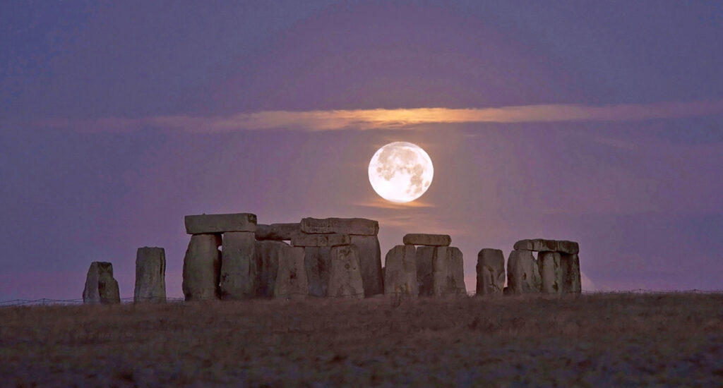
The stunning image above of moonrise over Stonehenge is thanks to The Great West Way,